
Every few years, I have posted maps of every country, U.S. state, and U.S. county I have ever been in. It is time for an update.
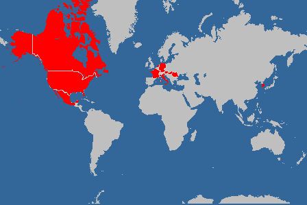
Since I last posted, in August 2009, I have added one country (South Korea), zero states, and thirty-one counties (in Kansas, Nebraska, Maryland, Pennsylvania, Washington, and Arizona). I do not have any airport-only countries or states, but I do have one airport-only county (Queens, New York), and one port-only county (Norfolk, Virginia).
World map — 11 countries:
U.S. map (states) — 46 states:

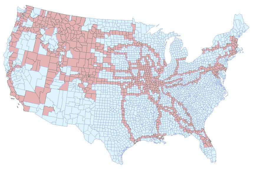
U.S. map (counties) — 931 out of 3109 counties (excluding Alaska and Hawaii):
I believe that this is pretty accurate, especially after about age ten. I can remember, for example, the route my family took for family vacation from Montana to California and back in 1973 when I was twelve years old. I also remember the routes of some long bus rides: Billings, Montana to New Orleans for a national Lutheran youth gathering in 1976 (?), and Bozeman, Montana to Daytona Beach, Florida for a Campus Crusade for Christ conference in 1982.
I have lived in Montana, Utah, Montana again, Washington, Missouri, Romania, Colorado, Missouri again, and Montana again.
Since I was in my early twenties, I have kept track of my travels with a highlighter in Rand McNally road atlases. I’m on my second highlighted atlas, and it is getting rather worn.

I was able to create the “Counties I’ve Been In” map by looking at which counties had highlighted roads in the the atlas.
Grace and Peace, from a map nerd.

Cool! I am not as well-traveled as you are. However, I have talked to people on every continent via amateur radio. And that includes Antarctica! I have “visited” by radio places in Africa such as Mali and Libya.
I haven’t commented here in a long time. I was disgruntled by the Lutheran Church Missouri’s stance on Young Earth and I think I made a few comments months ago about that. I am now going to an Anglican church and am happy.
LikeLike