
All I got from Mt St Helens (MSH) in the days following its May 18, 1980 eruption was a few pretty sunsets. I was an undergraduate student in my first year at the University of Utah, and most of the ash cloud passed far north of Salt Lake City. MSH became more significant for me a few years later as a geology graduate student at Washington State University, where my research project involved analysis and correlation of Cascade Range tephra (volcanic ash) layers buried at various levels in the Quaternary Palouse Loess of eastern Washington. Some of these tephra layers correlated to ancient eruptions of MSH, dated around 13,000 and 36,000 years ago.
Fortieth Anniversary
Due in part to easy accessibility, the 1980 eruptions of MSH have been studied more closely than just about any other explosive volcanic eruption in history. Geologists have learned a great deal about certain types of volcanic deposits from this natural laboratory.
Young-Earth creationists (YECs) claim that Mt St Helens has provided many proofs that Noah’s flood could have been responsible for Earth’s sedimentary rock layers, fossil record, landforms, and more. May 18, 2020 marks the fortieth anniversary of the 1980 eruption of MSH, and I would like to look at what some of these YEC claims are, and whether the claims are valid. Three YEC arguments I will look at are:
- Rapid formation of volcanic sediments at MSH show that Earth’s sedimentary rock record could have been deposited during Noah’s flood.
- Rapid canyon formation at MSH establishes that other canyons, such as the Grand Canyon, could have formed during Noah’s flood.
- Logs associated with Spirit Lake demonstrate that fossil forests and coal in the geologic record could have been formed by Noah’s flood.
It turns out that each of these arguments is of limited validity. The MSH eruptions had an impact on geological thinking at a time when geologists were becoming more aware of catastrophic events in Earth history, but this does not confirm the claims that YECs make about MSH.
MSH and Rapid Sedimentation
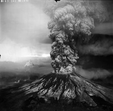
The May 18, 1980 eruption of MSH did not involve extrusion of fountains or rivers of lava flowing over the landscape. Instead, this was an explosive eruption, ejecting volcanic ash particles high into the atmosphere, as well as ground-hugging pyroclastic flows that blasted northwards from the volcano.
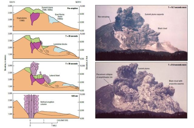
Pyroclastic flows consist of fast moving, hot volcanic gases mixed with blobs of molten material, volcanic glass, minerals, and rock fragments. This material may be hotter than 400°C (750°F), flowing across the landscape at hundreds of miles per hour. As the hot cloud of material slows down, grains settle out of the current, forming layers with sedimentary structures such as graded bedding and cross-bedding. This is sort of a hybrid between a volcanic and sedimentary process, producing what are known as volcaniclastic deposits. Another type of deposit from this eruption was volcanic mudflows known as lahars. Lahars form when precipitation or snowmelt mixes with loose volcanic ash to make a thick slurry of material that may flow tens of miles away from the volcano.
YECs have used these deposits as evidence that rapid, catastrophic processes can lay down sediments with features that are common in Earth’s sedimentary rock record. If MSH could create layers of rock complete with cross bedding and graded bedding in a short amount of time, why couldn’t the entire sedimentary rock record, many thousands of feet thick in places, have been deposited by a much larger catastrophic event, namely Noah’s flood?
The deposits of MSH do indeed show that volcanoes can do a lot of geologic work in a short amount of time. It did not take the 1980 eruptions of MSH to demonstrate this, and no geologists were taken by surprise. Any good volcanologist or sedimentologist will be able to recognize similar volcano-associated rocks in the rock record. Volcaniclastic rocks are common, and are thousands of feet thick in places. Rocks in some of the northern areas of Yellowstone National Park, as well as surrounding areas to the north, east, and southeast, are composed largely of volcanic rocks of the Absaroka Volcanic Supergroup. These rocks are older than and unrelated to the volcanic rocks of the more recent Yellowstone Caldera. The Absaroka rocks include lahars (mudflows), andesite lava flows, pyroclastic flows, and more coarsely crystallized rocks associated with magma chambers. By studying the flows, magma chambers, and associated dikes, geologists have concluded that some of the volcanoes must have been stratovolcanoes the size of the major Cascade Range volcanoes, such as Mt Shasta or Mt Rainier. Studying the products of the 1980 eruption of MSH has helped geologists understand these ancient volcanic rocks better.
How much contribution has the study of MSH had to the understanding other types of sedimentary rocks? Just about none. This is because most sedimentary rocks in the geologic record are quite unlike the volcaniclastic rocks produced by catastrophic processes at MSH. Most sandstones and conglomerates are nothing like the deposits of MSH. Yes, many sandstones have sedimentary structures such as cross bedding and graded bedding, but these are known to form in many non-catastrophic settings. Other sedimentary rocks have even less resemblance to anything associated with MSH. Most limestone is formed by biological processes, such as the secretion of calcium carbonate shells and other hard parts by invertebrate organisms. Most shale must have been deposited in quiet environments, as clay does not rapidly settle out from agitated water. Evaporite rocks (rock salt, gypsum, etc.) also have no analogs at MSH.
The conclusion is that most rocks in the sedimentary rock record were formed by processes that must have been quite different than what happened at MSH in 1980, and many layers were deposited in settings that have little to do with catastrophism. MSH tells us little about how most sedimentary rocks of the geologic rock record originated.
MSH and the Rapid Formation of Canyons
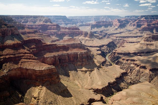
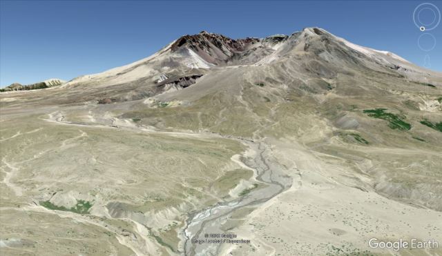
In addition to depositing pyroclastic and mudflow deposits, there are erosional features associated with eruptions of MSH. In 1982, rapid snowmelt led to severe flooding at MSH, which carved a 100-foot deep canyon north of the gaping crater in just a few days. This canyon is known informally as Step Canyon, and YECs claim it is a 1/40th scale version of the Grand Canyon in Arizona. YECs then argue that if snowmelt at MSH could lead to the rapid erosion of Step Canyon, then certainly the much larger Noah’s flood could have carved the Grand Canyon in a short period of time as well.
There are multiple problems with this reasoning. It sounds impressive to say that there is a 1/40th-scale version of the Grand Canyon, but this ratio is misleading. At its deepest point, Step Canyon is a little over 100 feet deep, which is roughly 1/40th the depth of the Grand Canyon, so perhaps that is where YECs get that ratio. For much of its length, the Grand Canyon ranges from 5 to 10, and up to about 18 miles wide. The canyon at MSH is less than 0.1 miles wide, which is about 1/50th the width of the narrower sections of the main part of the Grand Canyon. Finally, the Grand Canyon is about 275 miles long, whereas Step Canyon at MSH is about 4 miles long from the crater to its intersection with Engineer’s Canyon. The National Park Service says that the volume of the Grand Canyon is 4.17 trillion cubic meters. I made a rough estimate that Step Canyon at MSH has a volume of about 40 million cubic meters. This means that the volume of the rapidly formed MSH canyon is about 1/100,000th the volume of the Grand Canyon, which is not quite as impressive to readers as saying it is 1/40th the size.
A second difficulty for the YEC claim is that the Grand Canyon was carved through thousands of feet of solid rock, including crystalline metamorphic and igneous rocks at the bottom of the canyon. Most of the erosion at Step Canyon at MSH, on the other hand, was through unconsolidated sand and gravel. It should be obvious that comparing erosion through sand and gravel to erosion through schist and gneiss is comparing apples and oranges.
A final challenge is that Step Canyon at MSH developed on a steep slope, which facilitated rapid erosion. The average gradient of the Colorado River in the Grand Canyon is only 8 feet per mile. Step Creek, on the other hand, drops 2300 feet in 4 miles, which is about 575 feet per mile. Erosion on a steep, unconsolidated slope is certainly going to be far more rapid than erosion along a low-gradient streambed in erosion-resistant rocks.
While the rapid erosion of canyons at MSH is impressive, it falls far short of providing an effective model for carving the giant canyons of the world in only a few months’ time.
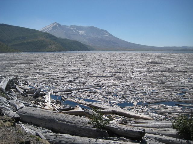
MSH and Fossil Forests
The pyroclastic flows associated with the May 18th eruption downed or burned trees up to 19 miles (31 km) from the volcano. A large number of trees ended up floating in Spirit Lake, where many continue to float on the lake surface forty years later. Some of the trees are floating in a vertical position rather than horizontally. The trees of MSH have provided a good analog for understanding fossilized trees in some ancient volcanic deposits. The Absaroka Volcanic Supergroup mentioned earlier contains abundant petrified trees in some areas, such as at Specimen Ridge in Yellowstone National Park. Many of these petrified trees are upright, which used to be interpreted as meaning that the trees were buried where they grew. Now, largely due to studies at MSH, we understand that trees can be ripped out of the ground, transported, and deposited in an upright position at a distance from where they grew.
YECs have claimed that this is powerful evidence that a giant catastrophe like Noah’s flood could have deposited the forests at Yellowstone. This is a great overstatement. What MSH demonstrates is not that the fossil forests at places like Yellowstone were deposited by a giant water flood, but that they were deposited in a volcanic environment like MSH. The Absaroka rocks are clearly volcanic in origin, with features I described earlier. These petrified trees were transported and buried by the local catastrophes of eruptions at stratovolcanoes, just as the trees at MSH were transported and buried by the eruption of a volcano.
YECs also claim that dead tree material is accumulating at the bottom of Spirit Lake at MSH, and that this will turn into peat, which is a precursor to coal. Perhaps this will form peat, or a peat-like deposit, but there are plenty of other non-catastrophic environments where peat is accumulating faster than at Spirit Lake. The world’s coal deposits as a whole, however, have little in common with the floor of Spirit Lake, which is not a very large lake. Most coal is found in sequences of sandstone, siltstone, and shale that give every appearance of being swampy environments such as river floodplains or deltas. The closest thing to a catastrophe in these environments would be a normal flood or channel migration. No MSH-sized catastrophe is needed.
MSH and the Bible
As an old-Earth Christian, I accept the Bible as the trustworthy and authoritative Word of God. I not only believe that God created the universe from nothing, I believe that Noah’s flood was a real, historic event. I do not accept the idea that the story of Noah is some sort of inspired myth, but that it really happened.
YECs claim that MSH helps “prove” that a global Noah’s flood really occurred, and that the Bible is true. I think this effort is misguided for three general reasons. The first of these is that, like many inerrancy-affirming Old Testament scholars, pastors, and scientists, I am not convinced that Genesis 6-9 even requires a global flood like the YECs envision. Entire books have been written on this subject, but the case for some sort of local (though still large) flood can be summarized as 1. The story is told from the perspective of Noah on Earth’s surface, not in orbit around spheroidal planet (which the Hebrews may have had no concept of), 2. The vocabulary in the flood account is more ambiguous in Hebrew than it is in our English-language translations, and 3. Universal language in the Old Testament is frequently hyperbolic. In other words, “all the earth” seldom literally means “all the earth” in the Old Testament.
A second reason why I do not think all these YEC attempts to explain Earth history are valid is that the flood account in Genesis tells us nothing about the geological work of Noah’s flood. The Bible makes no claims about the origin of sedimentary, igneous, or metamorphic rocks. It makes no claims about the origin of the fossil record. It makes no claims about the eruptions of stratovolcanoes, the carving of canyons large or small, or the deposition of fossil forests. The entire YEC flood geology story, exemplified by their claims about MSH or the Grand Canyon, is built on extrapolations from the text of Genesis, rather than on actual exegesis of the text.
Finally, YEC flood geology does not provide a credible model for explaining the origin of features of Earth’s crust. I have shown that the eruption of MSH tells us little or nothing about the origin of sedimentary rock layers, canyons, or fossil forests. Most sedimentary rocks are nothing like deposits formed by volcanic eruptions, the canyons at MSH do not demonstrate that Earth’s large canyons could have formed quickly, and MSH provides a model for petrified forests in volcaniclastic rocks, but not much else.
What claims does the Bible make about the work of Noah’s flood? None, really. The truthfulness of the Bible does not depend on whether or not MSH provides a model for Noah’s flood. In reality, MSH provides a model for understanding certain ancient volcanic eruptions, but not much else. YEC claims about MSH and the Noah’s flood are based on unwarranted extrapolations from the text of Genesis rather than exegesis of the text of Genesis.
Grace and Peace
©2020 Kevin Nelstead, GeoChristian.com
Notes:
A printer-friendly PDF of this article may be downloaded here: Mt St Helens 40th Anniversary
Featured image credit: Lyn Topinka, USGS, Public domain

Reblogged this on Peddling and Scaling God and Darwin and commented:
A very good summary of the geology of Mt St Helens, criticising creationist misunderstandings
LikeLike
h/t Michael, re-blogged with extensive commentary at https://paulbraterman.wordpress.com/2020/05/19/what-does-mt-st-helens-teach-us-about-noahs-flood-almost-nothing/
LikeLike
I completely agree with your analysis of Young-Earth creationist’s reasoning on Mt. Saint Helens concerning the Biblical flood and geology. I also must disagree that the flood was not global, based on other geologic considerations and the words of the Bible. I respectfully submit for your consideration an alternative hypothesis: (see: https://www.kjvbible.org/geysers.html)
LikeLike
Leaving aside your fantastical geology, let me just say that you sent me back to the Hebrew of Genesis 6:13 and it is clear that the Hebrew “eth”, which denotes the object of a verb, could be understood as “with” in the sense of “along with”, but not, as you suggest, “by means of”. “With” has both these meanings in English, so that the KJV can indeed bear the interpretation you put on it, but to the best of my knowledge there is nothing of the kind in Hebrew
LikeLike
Reblogged this on A Pilgrims Ramblings.
LikeLike
That’s an erroneous explanation as the article keeps harping on the difference between sedimentary and volcanic evidence not consistent with Noah’s flood but what’s completely missed is that there WAS enormous volcanic activity during Noah’s flood especially around what’s called the “ring of fire” which coincidentally also created the continents we have today. So of course we’ll find igneous volcanic rock all over the world. Also there was one great Ice Age that was the result of these multiple massive volcanos that spewed a megaton of ash and pollution blocking the sun for a long period of time drastically affecting the climate to a much cooler world.
LikeLike